Babatha's Orchard
Province
Arabia Petraea
Arabia (province) (Pleiades)
The history of Roman Arabia begins with the death of the Nabataean king, Rabb'el II Soter, in A.D. 106. The emperor Trajan annexed the Nabataean kingdom and organized its territory within the new Roman province of Arabia Petraea that occupied a large area of northwestern Arabia, extending from the Hauran in the north, to the Negev and Sinai deserts in the west, and into the northern Hejaz in the south. The administrative district of Perea, formerly under the Herodian dynasty was also added. The provincial capital of Arabia Petraea was located at Bostra which replaced Petra as the capital of Nabataea in the last decades of that kingdom’s independence. Petra continued to function as an important cultural, political and economic center of the province for at least a century following annexation. During the early Byzantine period (4th-6th centuries CE), the major cities of the Roman era continued to flourish, and Christianity gradually became the accepted religion of the area. Petra remained an important center in the early Byzantine period when it was inhabited by a substantial Christian community and was the seat of a bishopric.
The region of Arabia Petraea is primarily a desert environment that belongs to the eastern Mediterranean weather system. Its inhabitants experienced marked seasonal contrasts with dry, hot summers and cold, wet winters. Rainfall occurs during the winter months and ranges from over 600 millimeters in the north-west to as low as 100 millimeters in the south and east of the region.
Location
Maoza, near Zoara
Zoara (Pleiades)
Babatha's orchard was located in a village by the name of Maḥoz 'Eglatain (Aramaic for "harbor of 'Eglatain"). Alternative names on record are Mahoza and Maoza (Greek Μαωζα). While the exact location of the site is not known, descriptions in the ancient sources place it on the southeastern coast of the Dead Sea, near the mouth of Wadi Hasa (Biblical Zered). Maoza functioned as the harbor for nearby Ẓo'ar/Zoara (Greek Ζοαρα; modern Ghor el-Safi) (Esler 2017:pp. 66-67), which was the administrative center of the Zoara district of Arabia Petraea (Fig. 1).
Garden
Babatha's Orchard
Keywords
Garden Description
Babatha's orchard is known only from its documentation in a collection of papyrus scrolls known as the "Babatha Archive" that was discovered in 1961 in the Cave of Letters near the Dead Sea. Babatha was among a group of Jewish fugitives who took shelter in the cave near the end of the Bar Kokhba Revolt (15-135 CE). While in hiding, Babatha buried a cache of her personal possessions that included thirty-five legal documents dated between 94 CE and 132 CE. It is assumed that, soon after, Babatha was taken prisoner or killed by Roman soldiers.
One scroll in the Babatha Archive, (P. Yadin 3), records in Nabataean Aramaic the purchase of a date-palm orchard by the Judean, Shim'on ben Menahem, in December 99 CE. The property is described as located in the village of Maḥoz 'Eglatain (Maoza) with "its boundaries to the east, the road; and to the west, the houses of Ḥunainu, son of Tayim-'Illahi, and the houses of Taha, the daughter of 'Abad Ḥaretat; and to the south, the orchard of our Lord, Rabb'el. the King, King of the Nabataeans,..., and to the north, the swamp," the latter seemingly referring to the murky Dead Sea coastline (Fig. 2). The purchase included the date-palm orchard along with its irrigation ditches and its assigned watering periods, "half of one hour on the first day of the week." (translations from Esler 2017:247). The perenial stream that flows through Wadi Hasa is the likely source of irrigation water for Babatha's date-palm orchard and other crops in the village of Maḥoz 'Eglatain (Maoza).
Some years later, Shim'on ben Menahem transferred ownership of the property to his daughter, Babatha. When she registered the land with the Roman census in Deceber 127 CE (P. Yadin 16), it is described as divided into two adjacent orchards and given the name "Algiphiamma" (Aramaic for "by the seashore").
Maps
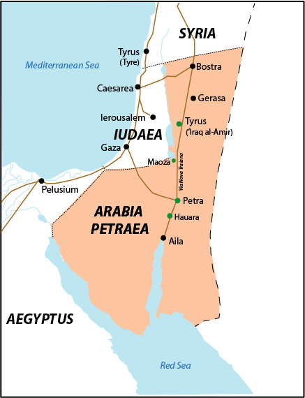
Fig 1: Map showing the approximate location of Babatha's orchard in Maoza in Arabia Petraea. Map by L.-A. Bedal, based on Andrein, with the assistance of EraNavigator
Plans
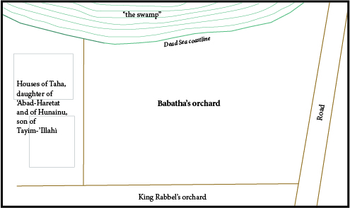
Fig 2: A proposed plan of the date-palm orchard described in Babatha's Archive. Plan by L.-A. Bedal (based on Esler 2017:Fig. 7.2)
Images
Dates
99 BCE - 135 CE (Roman period)
Bibliography
Esler, P. F. 2017. Babatha's Orchard: The Yadin Papyri and an Ancient Jewish Family Tale Retold, Oxford. (worldcat)
Lewis, N., et al. 1989. The Documents from the Bar Kokhba Period in the Cave of the Letters, Jerusalem: Israel Exploration Society. Pp. 65-68, Plate 13. (worldcat)
Periodo ID
Pleiades ID
TGN ID
Contributor
Publication date
February 5, 2022