Villa de Châtillon-sur-Seiche
Location
Garden
Villa de Châtillon-sur-Seiche
Keywords
- barnsAAT:300004900
- courtyards (uncovered spaces)AAT:300004095
- trenchesAAT:300008022
- fanumsAAT:300400628
- fountainsAAT:300006179
- hypocaustsAAT:300004277
- forecourtsAAT:300004104
Garden Description
Six kilometers south of Rennes, this village with medieval churches and pleasant promenades along the banks of the Seiche must once have been the site of castellum from which the name Châtillon derives. The fort was probably on a mound a few hundred meters southwest of the ancient farm and villa described here.
The evolution of this agricultural site can be followed from the period immediately following the Roman conquest up to its destruction at the end of the fourth century. The site lies 0.9 kilometers east of the center of the cloverleaf intersection of N 137 with D 34 in the Guyomerais area on the west side of Noyal-Châtillon-sur-Seiche. Rue des Potiers cuts through the site, with the pars urbana on the north and the smaller pars rustica on the south. The Rue de Condate bounds the area on the east. Known since 1904, the four-hectare site was excavated by Alain Provost between 1984 and 1988 prior to development of a residential subdivision.
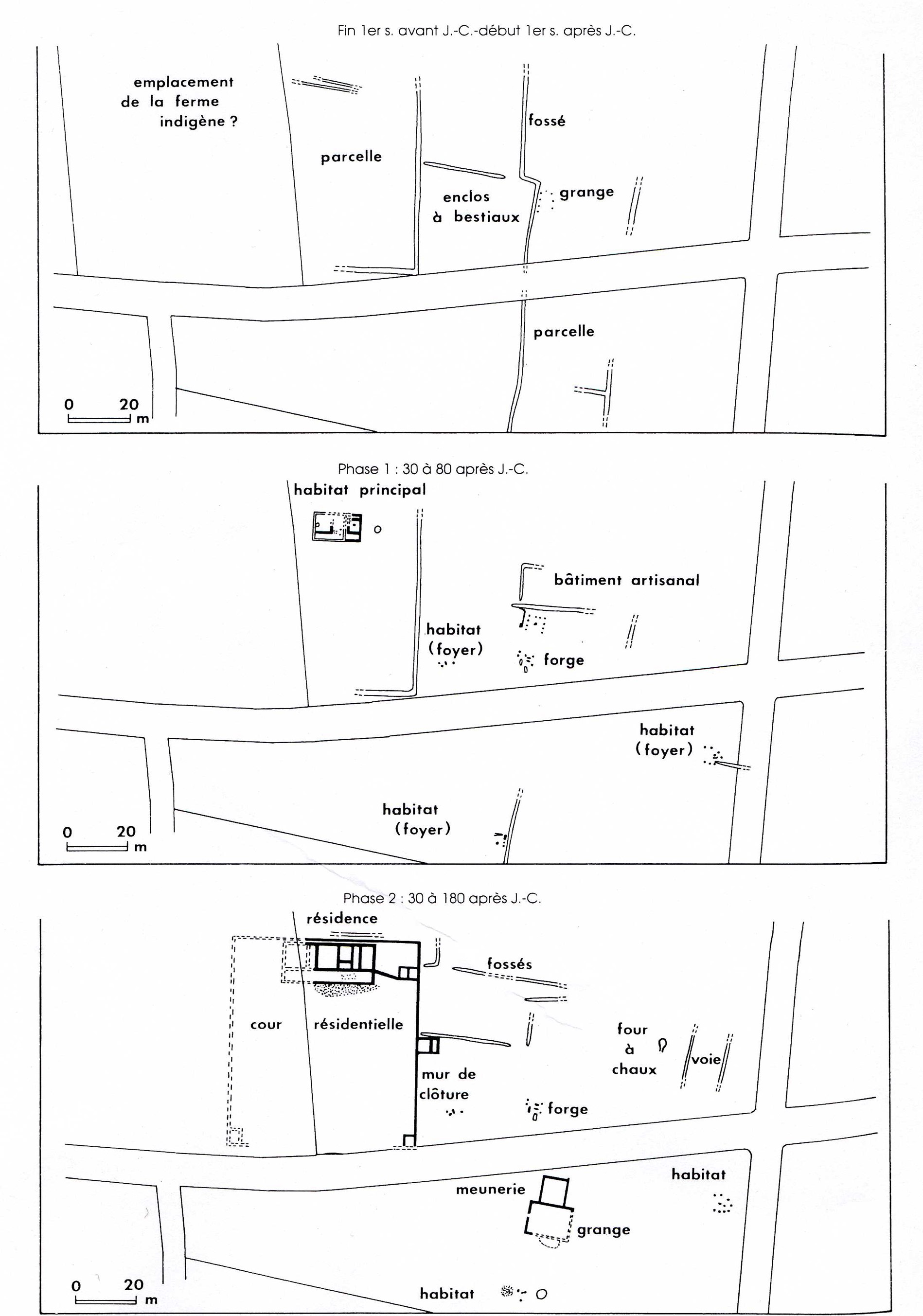
From a period immediately following the Roman occupation (from 20 BC to about 40 AD) date a stone enclosure for animals, some agricultural walls, and remnants of a simple barn.
A modest farmhouse (Phase 1) was built about A.D 30. To the south extended a courtyard (65 x 70 m), delimited by a trench, which may have had a garden. Outbuildings included a forge, a workshop, and three small homes with fireplaces.
About AD 80, the farmhouse was razed to make room for the first villa (Phase 2).Built of small stones, this villa consisted of five rooms in a line extending 26.5 meters along the north side of a gallery. A wall replaced the trench delimiting the courtyard. Outbuildings included a barn, a mill, and a chalk oven, in addition to the forge and homes.
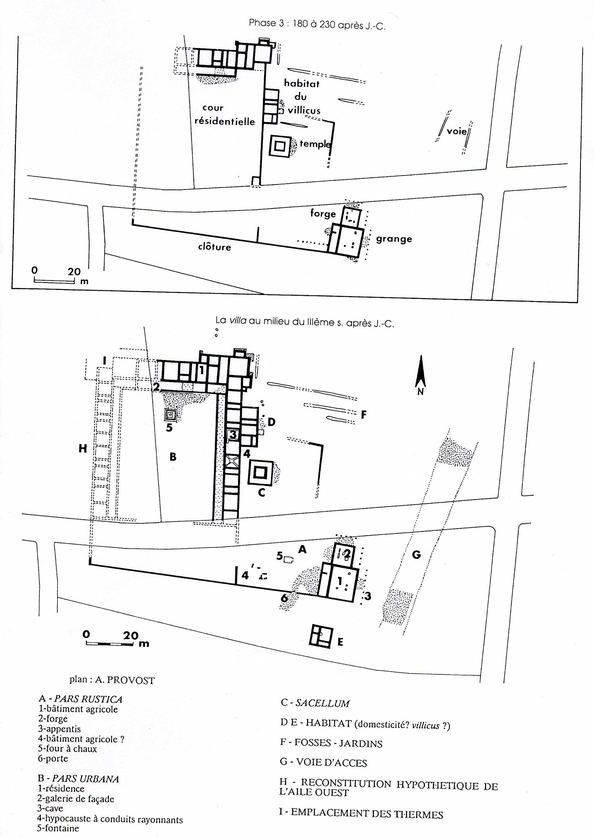
Then, somewhere around 180, residential structures were attached to the outside of the wall on the east side of the courtyard (Phase 3). They may have been the residence of the villicus. A little to the south and also outside the courtyard was built a square fanum, a type of temple thought to be of Celtic origin and consisting of a tower in a courtyard surrounded by a gallery.
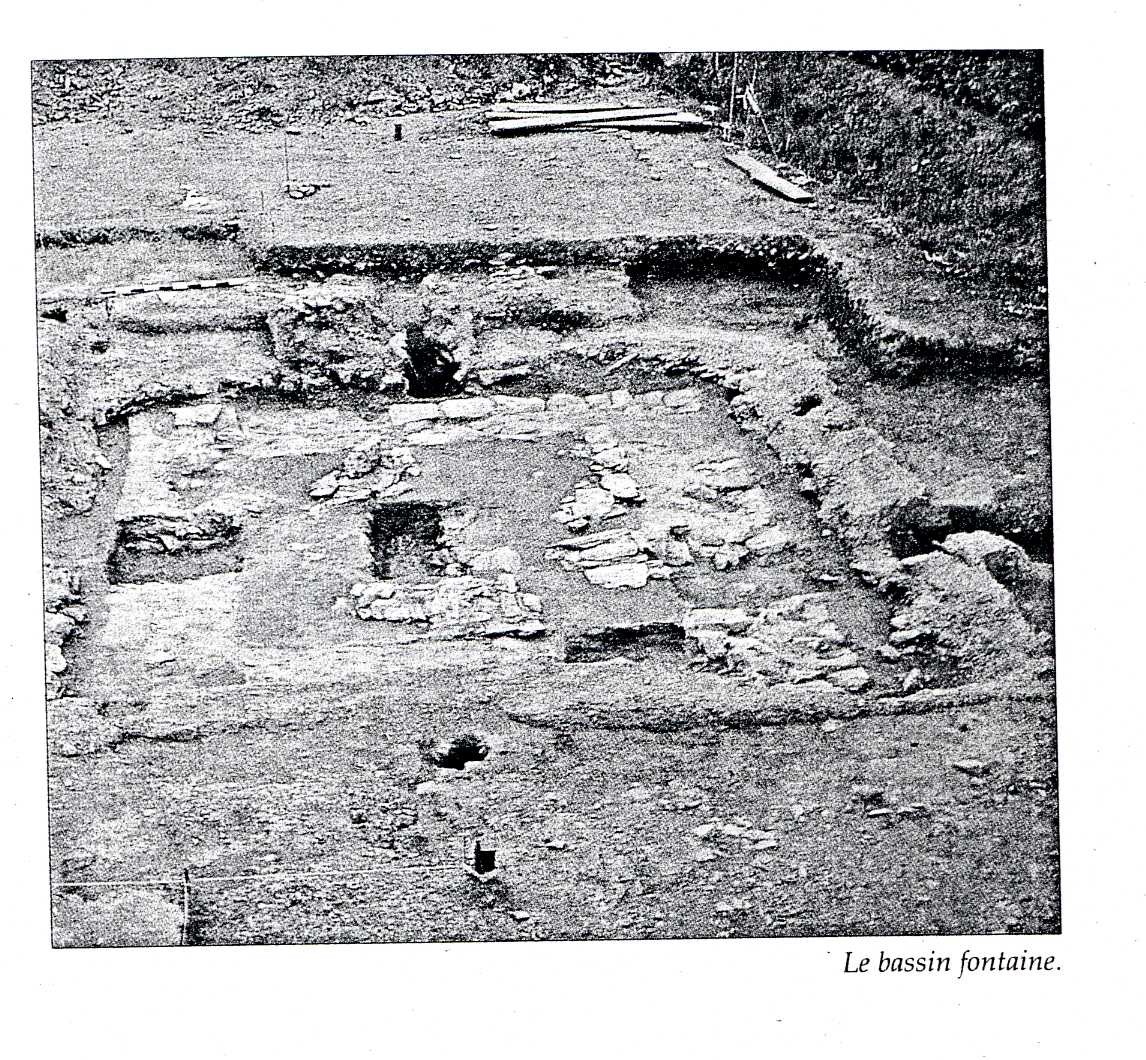
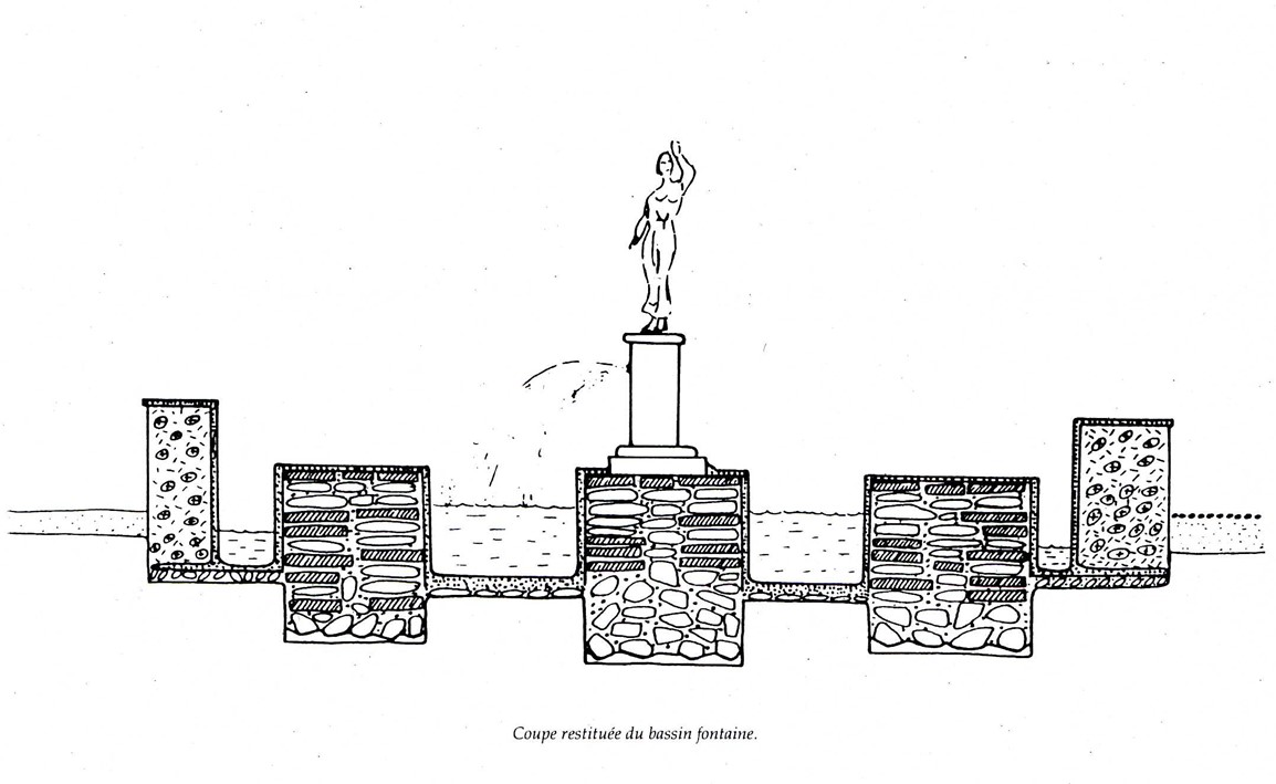
In the first half of the third century, the complex reached it apogee (Phase 4) with an enclosed courtyard of some 3000 square meters with a fountain in the north-south axis of the main reception room of the north wing.
It was possible to excavate only the eastern half and (on the south side of Rue des Potiers) the whole of the wall which closed the south side of the courtyard. At its southwest corner, this wall turned north at exactly the point required to fit a conceptual restoration of the west side as symmetric to the east with the fountain on the axis of symmetry. Along three sides of the courtyard (excluding the south) ran galleries with wooden supports on the courtyard side and a line of rooms on the outside. On the east side, one room was heated by hypocausts and one was a wine cellar. Since an access road was found on the east, the entrance to the courtyard was presumably on the east side of the forecourt on the south, in an area destroyed in the construction of Rue des Potiers.
The villa showed a certain level of refinement in decor. The fountain, lined with marble with decorative moulding, was formed by two masonry squares, one within the other. A central pedestal probably supported a water jet and possibly a statue. A few fragments of marble statuary were found, including the abdomen and buttocks of what may have been a cupid; but precise original locations could not be determined. Though there is no evidence of mosaics, wall painting with imitations of marble and porphyry was employed, as were some high-quality building materials such as slate and schist. Numerous fragments of bronze plumbing were found, along with collars for attaching metal pipes to wooden tubes and sections of pipe to carry away the waste water.
At the end of the third century, the pars urbana was abandonned, then partially re-occupied around 320-330 in the age of Constantine. Final total abandonment came at the end of the fourth century.
Was there a garden? Within the courtyard, there is no direct evidence of planting, but neither is there evidence of a hard surface that would preclude a garden, except that between the north gallery and the fountain there seems to have been a passage way. Outside the courtyard, northeast of the supposed house of the villicus, there were parallel trenches interpreted by the excavator as a garden zone (F on the Phase 4 plan).
A study of pollens and sediments below the levels of the Gallo-Roman villa in a paleosol dated to the late first century BC or early first century AD has revealed the environment of the farm at that time. It shows a soil already worked and gardened by man and the presence of pollens of cereals. The countryside, already totally or partially cleared combined various trees – pine, hazel, oak, holly and linden – with ferns and herbaceous plants, especially grasses and plantains characteristic of prairies and grasslands. A comparison with the quantities of pollens found in the soils of the villa in the second and third centuries shows relative stability of the percentages, as shown in figure 5. While interesting, these findings describe the environment rather than the gardens themselves.
Maps
Plans
Images
Dates
Unspecified
Bibliography
- Alain Provost, "La villa gallo-romaine de Chatillon-sur-Seiche," in the catalog of the exposition Nos ancêtres les Riedones, Musée de Bretagne- Eco-musée du pays de Rennes, Rennes, 20 juin, 31 déc. 1990, p. 10-31 (worldcat)
- Gilles Leroux, Alain Provost, CAG- Ille-et-vilaine (35), p. 270-274. (worldcat)