Edifice of the Platform
Province
Province Description
Ancient Roman colony (founded 118 BCE) and senatorial province located in modern southern France, along the Mediterranean. This province had stronger cultural and political ties to Italy than the rest of Gaul.
Location
Sublocation
Garden
Edifice of the Platform
Keywords
- vestibulesAAT:300083076
- courtyards (uncovered spaces)AAT:300004095
- peristyles (Roman courtyards)AAT:300080971
- cisterns (plumbing components)AAT:300052558
- opus sectile (visual works)AAT:300254462
- porticoesAAT:300004145
House Description
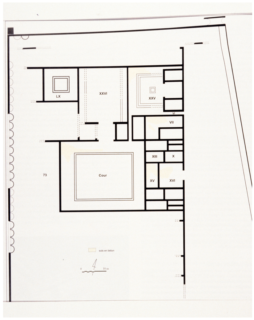
This construction is situated in the southeast corner of Network B of the town plan, near the port. The parcel has a surface 8,422 square meters with 6,860 for the habitation properly speaking and a covered useful surface of 3390 square meters. The present construction goes back to the end of the first century B.C., between 30 and 10 B.C., but there was an anterior condition. The edifice was lavishly decorated and underwent multiple rearrangements in second century and then again in late antiquity.
At the north, a large vestibule gives access to a vast courtyard with a peristyle [2] of 41.5 meters by 45 meters around which the residence is organized. This court was not a garden but rather was paved with flagstones and sloped, according to Charles Texier, to collect the rain water into a mighty central subterranean cistern that was covered by a rectangular ornamental pool of 9.5 by 12.5 meters. This cistern would have made the residence self-sufficient in water. The peristyles and courts that led to the apartments with many rooms seem also to have had no gardens, for the surface was hard, either of concrete or opus sectile. It is on the outside that a garden would have been developed, on the south façade of the construction along a portico or gallery; the garden [26] of 900 square meters of arable land was limited by the rampart to the south. It would have offered a panorama on the port and plain.
Plans
Bibliography
Bouet, Alain. La Maison Urbaine D'époque Romaine: Atlas Des Maisons De Gaule Narbonnaise. Vaucluse: Service d'Archéologie du Conseil Général de Vaucluse, 1996, P. 94-96, fiche n°2, P. 104-105 (worldcat)
RIVET, D. BRENTCHALOFF, S. ROUCOLE, S. SAULNIER, Fréjus, Atlas topographique des villes de gaule méridionale, R.A.N., supplément 32, Montpellier, 2000, P. 251-257. (worldcat)
Places
- Narbonensis (province) Pleiades: 981537
- Gallia Narbonensis (province) TGN: 7030317
- Fréjus (inhabited place) TGN: 7008791