House of the Tizerine Cape (Maison du Cap Tizerine)
Province
Province Description
An ancient district of Africa in Roman times, Mauretania lay west of Numidia and covered most of present-day Morocco and western Algeria. By the second century BCE, when Jugurtha of Numidia was rebelling against Rome, Jugurtha's father-in-law Bocchus had most of Mauretania under his control. In 25 BCE Augustus appointed Juba II as ruler of Mauretania. Claudius divided it into two provinces: Mauretania Caesariensis, with Caesarea (modern Cherchel) as capital, and Mauretania Tingitana, with Tingis (modern Tangier) as capital. By the end of the 5th century CE, the province had disappeared.
Location
Location Description
A prestigious city on the southwestern shore of the Mediterranean Sea, Caesarea is located approximately 100 km west of Algiers. Situated on the border of an upland plain dominating the sea and bordered on the west and east by the mountains of the Chenoua and of the Cape Ténès, respectively, the city was one of the ports that the Carthaginians established on the coast of the Maghreb.
The city was originally known as Iol. Just after the fall of Carthage during Julius Caesar's reign, the city was controlled by African dynasties and later became the capital of the amalgamated Massyle kingdoms ruled by Micipsa (son of Massinissa) and Bocchus (king of the Maures and ally to Caesar). In 33 BCE after Bocchus' death, Rome annexed the kingdoms and entrusted them to a client king, Juba II. Juba was the son and successor to Hiempsal II, one of Pompey's allies. He was sent as a hostage to Rome in 25 BCE and later married Cleopatra Selenus, daughter of Cleopatra and Mark Antony. Highly learned, Juba was renowned for his achievement in transforming Iol into a Greco-Roman town, renamed Caesarea. Juba II was succeeded by his son, Ptolemy of Mauretania, who was murdered by Caligula in 40 CE. The city then became the capital of the province named after it, Mauretania Caesarea, the eastern part of Mauretania (the western part being a second province, Mauretania Tingitana), administered by a provincial governor.
Under Claudius the city became a Roman colony, Colonia Claudia Caesarea. The old Phoenician port was enlarged and expanded for military use, the most important such port in North Africa after Carthage. The city expanded, with 7 km of walls surrounding an area of about 370 acres. From the end of the second and through the fourth centuries, the city was a flourishing settlement. During the middle of the fifth century, Saint Augustine preached in the principal church. At the end of the fifth century, the city was conquered by Vandals, eventually being annexed by the Byzantine Emperor later during the sixth century.
The city has been continually occupied to the present day, now known as Cherchel. From the Roman period, many archaeological sites have survived, including temples, baths, houses adorned with mosaics and sculptures, a theater, a forum, a judiciary basilica, an amphitheater, a large hippodrome, and a lighthouse constructed on the islet of the city.
Garden
House of the Tizerine Cape (Maison du Cap Tizerine)
Keywords
- domusAAT:300005506
- peristyle housesAAT:300005452
- pools (bodies of water)AAT:300008692
- fountainsAAT:300006179
Garden Description
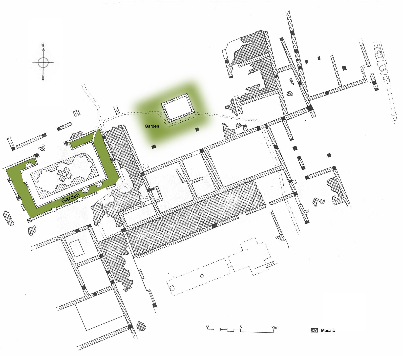
A large domus, about 2400 square meters, located on the cape of Tizerine, with three separate courtyards, one of which was a garden peristyle (Plan view, Fig. 1). The courtyard to the south, the largest, was partially excavated. Only three porticoes with low walls were visible. There was probably a basin in the open area but only a cruciform cistern was found underneath.
The northwestern courtyard was decorated with a large pool, which had a water spout in the shape of a pyramid. Inside the pool were recesses, of which six were semi-circular and the others were square-headed. A planter may have surrounded this elaborate pool.
The northeastern courtyard was most likely a peristyle-garden. There, a basin probably used for watering the little garden was excavated. It dates from second to third century.
Plans
Dates
2nd-3rd century CE
Excavation Dates
Bibliography
- Ballu, A., Rapport...en 1921, Alger 1922, p. 9. Rapport... en 1922, Alger 1923, p.7. Rapport... en 1923, Alger 1923, p.8. Raport ... en 1923, Alger 1924, p.8-9. (worldcat)
- Ferdi, S., Corpus des mosaïques de Cherchel, Etudes d'Antiquités africaines, Paris, 2005, p. 77. (worldcat)
- Lassus, J., "L'archéologie algérienne en 1959", in Lybica, arch., épigr., t.8, 2ème sem. 1960, pp.27-50. (hathitrust)
- Leveau, Ph., "Les maisons nobles de Caesarea de Maurétanie", in Antiquités africaines., t.18, pp.118-21. (worldcat)
- Waille, v, "Fouilles de Cherchel (1902-1903)", in Revue Africaine, t.47, 1903, p.102. (worldcat)