Building of the Three Basins (Edifice des trois bassins)
Province
Africa Proconsularis
Africa proconsularis (Pleiades)
Province Description
The history of Roman Africa begins in 146 BC with the destruction of Carthage and the establishment of the province of Africa in the most fertile part of the Carthaginian Empire. The new province covered about 5000 square miles (17,172 square kilometers) of the northern part of modern Tunisia. A praetor governed the area from his headquarters at Utica. The Romans inherited a thriving agriculture developed by the Carthaginians. The climate was hospitable. Wheat and barley were the most important cereals; wine and olive oil were also produced and there were various fruit trees.
Location
THUBURBO MAIUS (Henchir Kasbat), Tunisia
THUBURBO MAIUS (Henchir Kasbat), Tunisia (Pleiades)
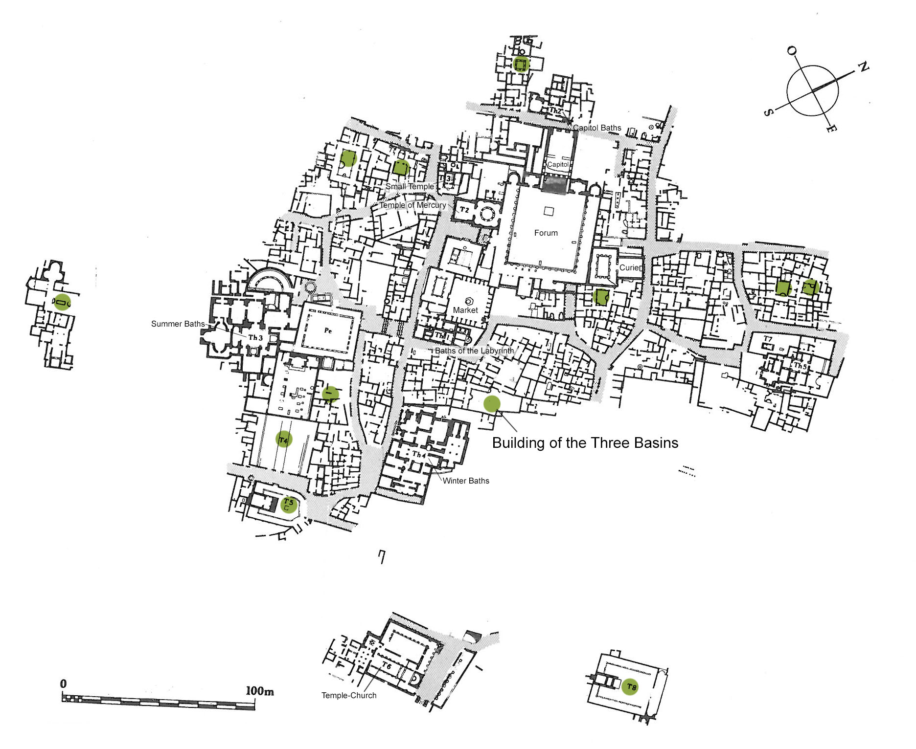
Plan of Thuburbo Maius (CMT, Thuburbo Majus)
Location Description
The city occupies the slopes of a hill in a fertile grain producing area about 50 kilometers to the south of Tunis. Originally a settlement of mercenary soldiers after the fall of Carthage, it was raised to a municipium by Hadrian (117-138), and to a colony during the rein of Commodus (177-192). The chief public buildings and the most beautiful homes date from this period. After the crisis of the Empire during the third century, Thuburbo saw a rebirth in the fourth century; but as imperial authority declined the city became a mere village.
Keywords
Garden Description
This building, located to the NW of the Winter Baths, was comprised of three articulated sectors, the SE area, the NW area, and the area to the N of the NW area.
The SE area was laid out around an incomplete peristyle with seven columns along the NW and SW sides (Plan view, Fig. 1). Three semicircular pools projected into a large courtyard. A first pool was located at the extremity of the NW portico (II) facing the main reception room V, and there was a third of which only traces survive. The large court (I) of irregular shape (ca 24x10m) was not paved and may have been planted.
Maps
Plans
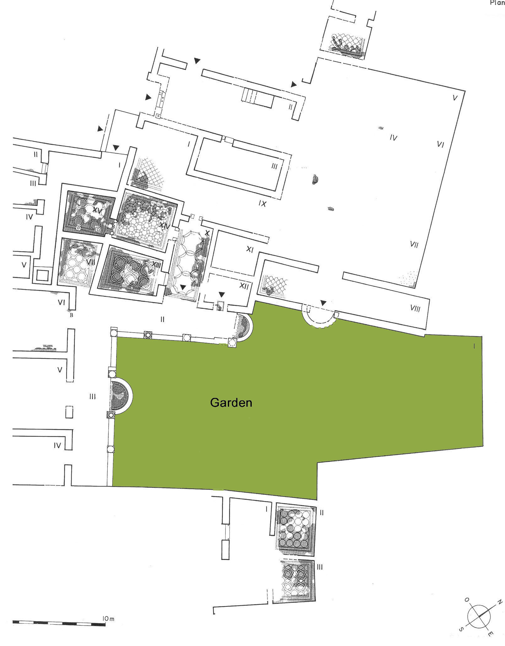
Fig. 1: Plan of the Bulding of the Three Basins (CMT, Thuburbo Majus, V. II, fasc.2, plan 19-20)
Dates
2nd-3rd century CE
Bibliography
- Ben Abed-Ben Khader, A., Corpus des Mosaïques de Tunisie, Thuburbo Majus, Les mosaïques de la région des Grands Thermes, V. II, fasc.2, INA, Tunis, 1985, pp. 101-13, plan 19-20. (worldcat)
- Ben Abed-Ben Khader, A., Corpus des Mosaïques de Tunisie, Thuburbo Majus, Les mosaïques de la région Ouest, V. II, fasc.3, INA, Tunis, 1987. (worldcat)
- Bullo, S., Ghedini, F., Amplissimae atque ornatissimae domus: l’edilizia residenziale nelle città della Tunisia romana, Rome: Edizioni Quasar, 2003, pp.230-232. (worldcat)
Pleiades_ID
TGN ID
Contributor
Publication Date
21 Apr 2021