Jericho Herodian Third Palace Ionic Peristyle
Province
Judaea
Iudaea (province) (Pleiades)
Province Description
Judaea, the Roman province, included parts of the areas of the Hasmonean and Herodian kingdoms, notably Biblical Judah, Samaria, and Edom. Its capital was Caesarea Maritima. Roman influence in the region began in 63 CE, when the Roman general Pompey the Great conquered Syria from Mithridates of Pontus, besieged Jerusalem, and captured the Second Temple; he appointed Hyrcanus, one of the two Hasmonean brothers fighting for kingship, as ethnarch of Judaea. Later, Julius Caesar appointed Antipater, the father of Herod, as Judaea's first Roman Procurator. Later these ties allowed Herod to seek backing from Rome against the Hasmoneans in 40 BCE, when the Senate recognized him as “king of the Jews.” His territories came to include the regions of Galilee, Gaulanitis (the Golan),Peraea and the Decapolis, and Augustus later granted him the coastal cities, Batanaea, Auranitis, and Trachonitis. Herod balanced his allegiance to Rome with the independence of his kingdom, often employing architectural projects to express his ambitions and control of nature to express his capacity to rule . His many palaces, placed strategically around the kingdom, feature dramatically designed landscapes and gardens. Upon his death, his son and heir Archelaus was unable to maintain order and the major part of Judaea was annexed to Syria in 6 CE, with its own prefect, while two other sons of Herod, Philip and Antipas, received territories as tetrarchs. By the time of Trajan, Judea was reduced in size and many of the Herodian palaces abandoned, preserving them over the millennia for archaeologists. Hadrian renamed the province After the Bar Kochba revolts (132-135)Hadrian renamed the province Syria Palaestina, erasing the name of Judaea.
The geography of Judaea comprises a wide variety of biomes, from richly watered plains of the Galilee and the Jordan, to the semi-arid Judean Hills, the humid, fertile coastal plain of the Mediterranean, and the deserts of the Dead Sea valley and the Negev. The period for which we have the richest evidence of a garden culture in this region is during the reign of Herod the Great. An allied king of Rome, Herod’s relationships with Mark Antony, Cleopatra, Augustus, and Marcus Agrippa and other officials ave been preserved in the texts of Flavius Josephus. These constitute a rare record of interactions between Rome and its territories, and provide a valuable context for understanding the trends of design in the early imperial period. The proximity of Judaea to Alexandria, whose palaces and gardens lie beneath the modern city and its harbors, may also provide a suggestion of the late Hellenistic garden culture that Romans emulated. Evidence of gardens in the Hasmonean winter palaces at Jericho and the palace identified as that of Hyracanus the Tobiad at 'Iraq al-Amir on the other side of the Jordan Valley provide rare cases where texts can illuminate archaeological evidence. These gardens require further investigation and both are threatened by local development.
Location
Location Description
In one of the most beautiful spots of the Eastern Mediterranean, five km west of Jericho, the biblical “city of Palms,” (Deut. 34:3) lie the remains of a royal complex of the late Second Temple Period (the end of the second century B.C. continuing through the mid-first century A.D). Despite their location in the desert some 200 m. below sea level (one of the lowest occupied elevations on earth) these palaces were set amidst an abundance of vegetation and enjoyed a copious supply of water brought from the surrounding hills via water channels. The palaces are dramatically situated along Wadi Qelt where the gorge opens abruptly onto the Jordan Valley floor. (Fig. 1) They were set amidst the large palm and balsam groves for which the valley was famed. Water channels give archaeological evidence of groves to the north of the palace, but literary evidence suggests that royal holdings from Jericho to Ein Gedi were extensive. None of the gardens have been fully excavated, but many have been examined and the presence of rich soil rather than pavement, as well as water channels and ceramic planting pots provide conclusive evidence for the many gardens discussed below.
Figure 1: Plan of the Hasmonean and Herodian Winter Palace Complex, Jericho (Gleason after Netzer)
Sublocation
Herodian Entertainment Complex, Third Palace
Sublocation Description
The third palace built by Herod in the late first century B.C. merits special mention with regard to the integration of water, gardens and landscape. This palace was sited along a straight section of Wadi Qelt to take advantage of its season flow of water each winter. This area was, however, lower than those on which the first and second palaces had been built, offering a more limited view of the surroundings. This shortcoming was offset by the erection of a viewing pavilion on top of an artificial tel. The overall building complex was rectilinear, with Wadi Qelt cutting through the center, and a bridge spanning the two halves. On the north side lay a complex of banqueting rooms, Roman style baths, reception rooms, peristyle courtyards and colonnaded walks. On the south lay a great sunken garden, the artificial tel and pavilion, and, off-axis, a shallow boating pool. (Fig. 2) The garden features are discussed individually below.
Figure 2: Plan of Herod’s Third Palace (K. Gleason after E. Netzer 2001a: Plan 48).
Garden
Royal Garden
Keywords
Garden Description
Ionic Peristyle
This peristyle courtyard (19.1 x 18.7) lies adjacent to the banquet hall and near Roman baths constructed in opus reticulatum. It is referred to in excavation reports as area B64. The central garden is surrounded on three sides by a colonnade of cemented stone, stuccoed in white and red. Remains of plaster Ionic capitals and other stucco decoration were found during excavation, as well as frescoes with floral motifs of unusually high quality, perhaps made by Roman craftsmen. Rozenberg claimed that this courtyard was the most richly painted space in the palace An unusual feature of the peristyles in this complex is an opus signinum walk around the inner circumference of the peristyle, outside the columns flanking the garden.
The garden was first discovered in 1976 by E. Netzer, who excavated a trench through the center of the peristyle. The garden soil was poorly preserved, but ceramic planting pots appeared at the bottom of the garden. In 1985 and 1987, K. Gleason continued the excavations and found preserved garden soil layers beneath the destruction debris at the sides of the garden. (Fig. 3 and 4) The stratigraphy is reconstructed as follows:
The subsoil, probably fill, is composed of coarse, poorly cemented alluvial pebbles and cobbles. Above this, a thin layer of soil, in most places, plastered over, formed a rough surface over the courtyard, except at the north end, where the plaster tapers off onto a packed earth surface. The crude quality of the plaster and varying types of mortar suggest a working surface for the construction of the peristyle. When the garden was installed, trenches extending down into the subsoil levels were cut out of the plaster surface for the pots and planting pits. (Fig. 5) The flower pots at Jericho are unusual among Roman era pots. They are well-formed of local clay with a hole in the bottom and three holes in the side of the vessel, neatly punched before firing. Their similarity to local water-wheel pots is striking, except that in the planting pot the knob-like foot is open, like a bottle top, while closed in the water wheel pots. The Mishnah suggests that perforated pots, with holes in the bottom and sides, allowed the plants inside to make contact with the ground and thus allow plants or seeds in the pot to be considered like plants in the ground in most matters of agricultural law (Mishnah 8 in Kil’ayim), purity (eg Uktzin 1.9-10), and tithing (Gitin 21b-22a). The rabbis, at least during the redaction of the Mishnah, found that flower pots posed fascinating problems for interpretation.
The plantings were aligned in rows, roughly 1.5m apart. Between the rows, ridges were formed of small cobbles crudely plastered over, apparently to direct the flow of irrigation water. At the north end the situation appears to be somewhat different. The ridges characteristic of the plastered surface end approximately 2m from the walk in front of the apse. In this area only one pot was found, but late in excavation, after light rainfall, three planting pits became evident. These were filled with a light sandy loam, and two were free of flower-pot sherds. The fertilized garden soil was then laid over the whole area, 8-10cm deep and surrounding the pots, but only on the surface of the planting pits.
The plan reveals seven rows of up to eleven pots per row, although directly in front of the apse, tree pits were observed in place of the pots. This regular ordering of rows seems peculiar in such a public location, as Roman gardens of this period could be quite ornate in their layout (Fig 7). A garden at Pompeii laid out in such straight rows would be a market garden. However, the older, Hellenistic and Persian preference is for straight rows, and it is possible that this is a display garden for miniaturized plants (Langgut and Gleason).
Plans
Figure 3: Plan of the Ionic Peristyle Courtyard B64 with the location of the planting pots (K. Wilczak and K. Gleason).
Images
Figure 4: Section extending from the Sunken Garden, through Garden B64, to the Southern Tell (K. Wilczak after Netzer 2001a: Ill. 478).
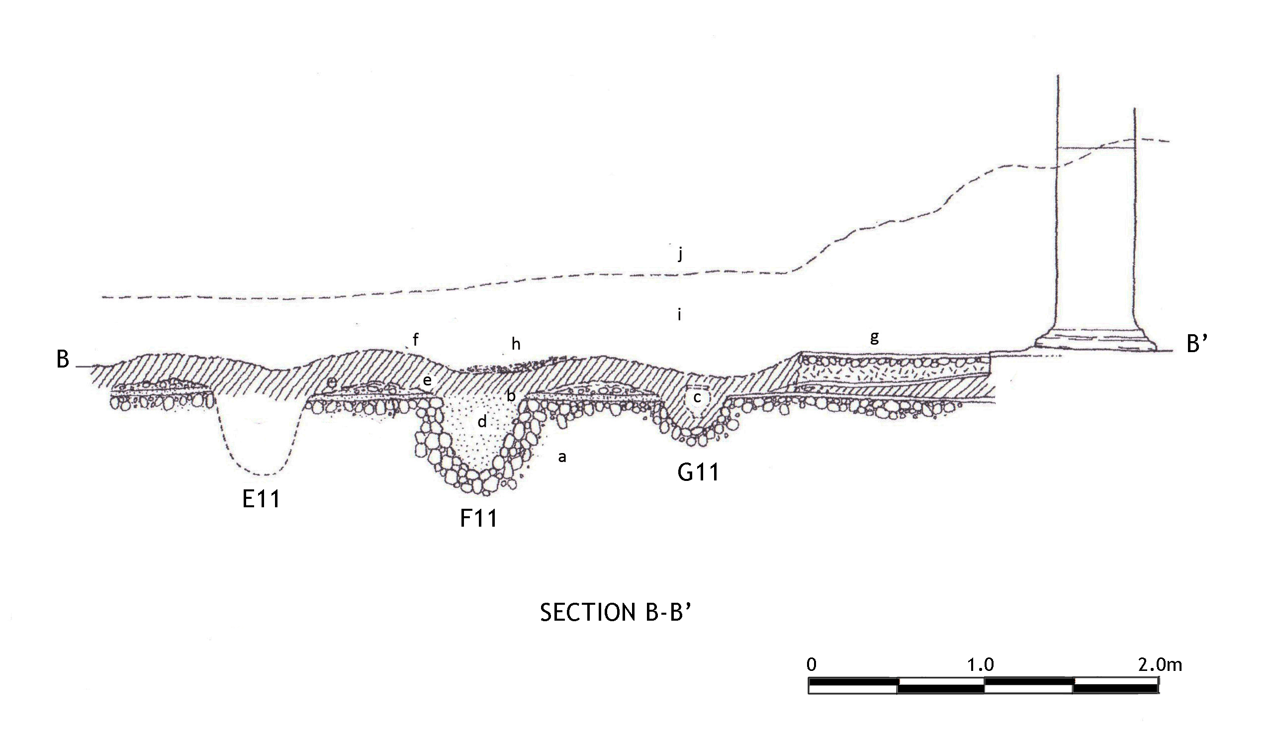
Figure 5: A section through the Ionic Peristyle Courtyard B64 at the second row from the north: (a) gravel subsoil; (b) working surface; (c) planting pot; (d) planting pit; (e) ridges; (f) contoured garden-soil surface; (g) sidewalk; (h) alluvial deposit; (i) fallen building debris; (j) modern surface in 1978–1985 (K. Gleason).
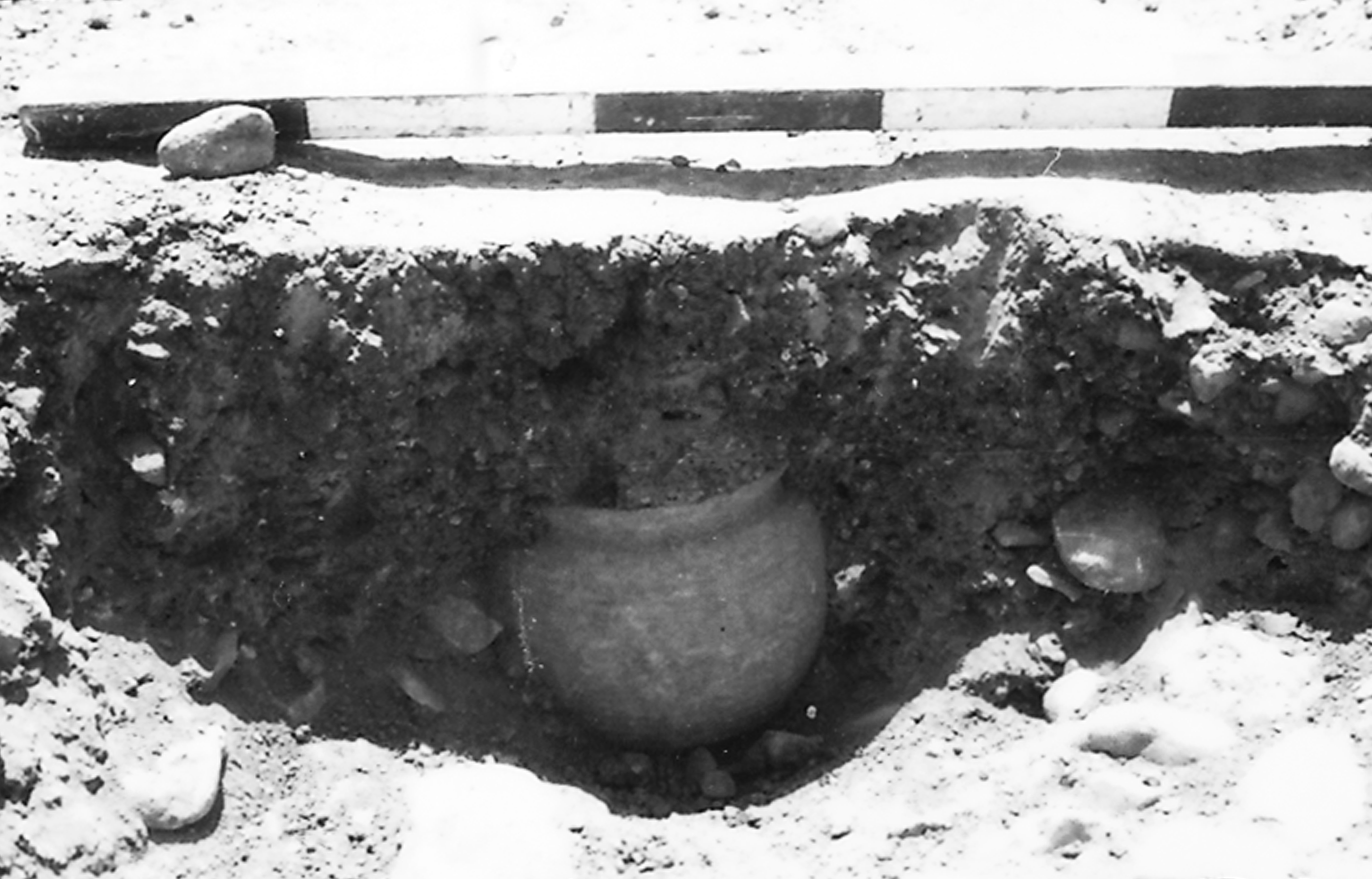
Figure 6: A planting pot No. 23 found in the Ionic Peristyle Courtyard B64 (K. Gleason).
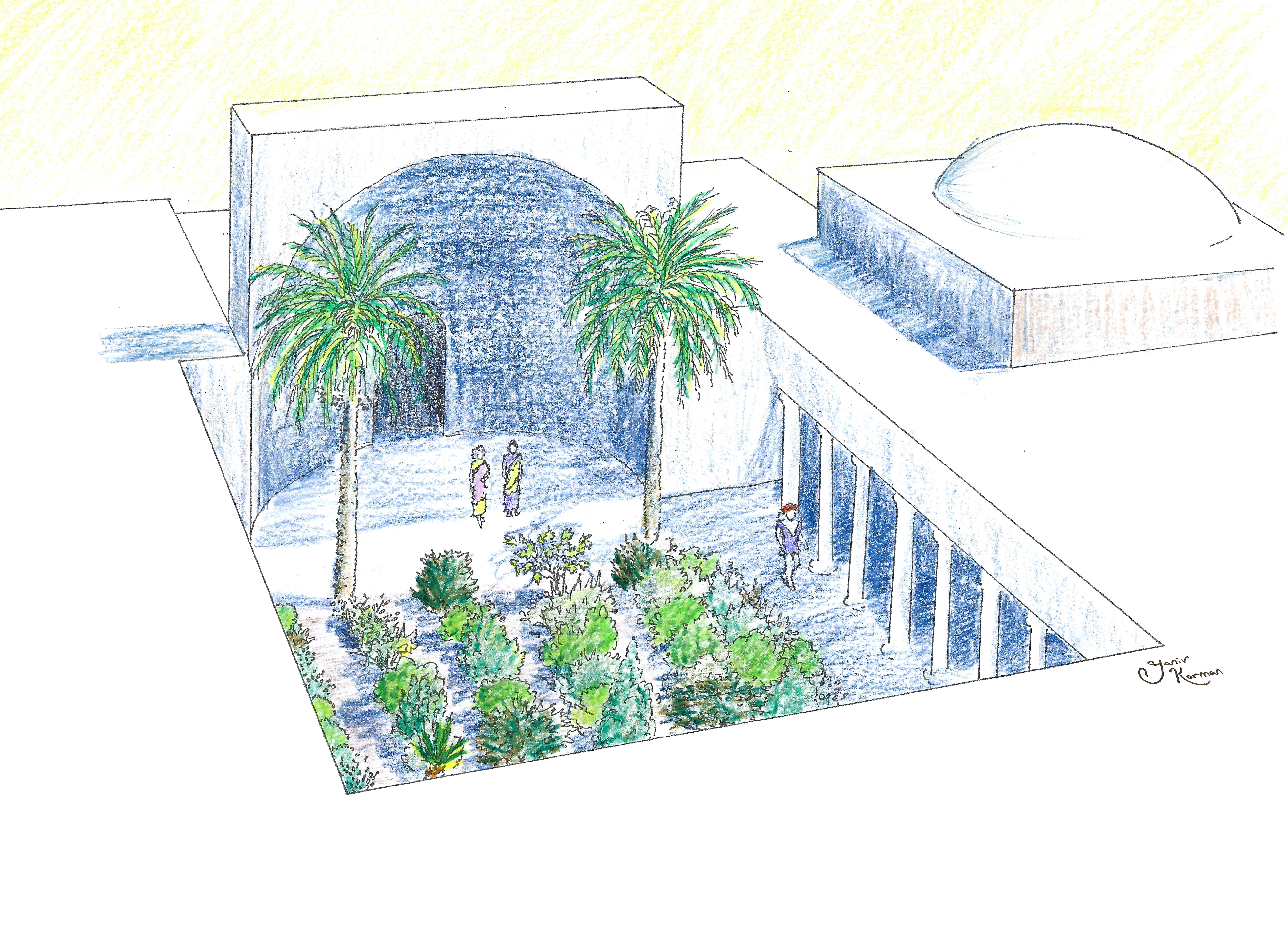
Figure 7: Axonometric reconstruction of the Ionic Peristyle Courtyard B64 with the location of the planting pots (Yaniv Korman).
Dates
31 BCE - 4 BCE
Bibliography
- G. Garbrecht, and E. Netzer, “Die Wasserversorgung des geschichtlichen Jericho und seiner koniglichen Anlagen,” in Mitteilungen (aus dem Leichtweiss-Institut fur Wasserbau) 115, Braunschweig/Jerusalem 1991 worldcat
- K. Gleason, “Garden Excavations at the Herodian Winter Palace in Jericho, 1985-1987", Bulletin of the Anglo-Israel Archaeological Society, Vol. 7, 1987-8 Jstor
- K. Gleason, “A Garden Excavation in the Oasis Palace of Herod the Great at Jericho,” Landscape Journal 12.2 (1993):156-67wordcat
- J. Kelso, James L. and Dimitri Baramki, “Excavations at New Testament Jericho and Kirbet en-Nitla,” Annual of the American Schools of Oriental Research 29-30 (1949-51): 38-39
- E. Netzer, The Palaces of the Hasmoneans and Herod the Great, Jerusalem: The Israel Exploration Society, 1999: 13-64 wordcat
- Nielsen, Inge, Hellenistic Palaces,1994, 195-201 wordcat
- E. Netzer, The Hasmonean and Herodian Palaces at Jericho: Final Reports of the 1973-1987 Excavations, Vol. 1, Jerusalem: Israel Exploration Society, 2001 : 287-298 worldcat
- E. Netzer, and Garbrecht G, “Water channels and a royal estate of the late Hellenistic period in Jericho’s eastern plains,” in D. Amit, J. Patrich and Y.; Hirschfeld, eds, The Aqueducts of Israel. 353-365. JRA Supplement 46, R.I. 2002 worldcat
- J. Pritchard, “The Excavation at Herodian Jericho, 1951," The Annual of the American Schools of Oriental Research 32-3 (1952-4): 56-58. worldcat
- Langgut D. and Gleason K. 2020. Identification of the miniaturized garden of King Herod the Great: The fossil pollen evidence, Strata.
Pleiades ID
Contributor
Kathryn L. Gleason (ORCID: 0000-0001-6260-8378
Publication date
21 Apr 2021